Bridgeport GBT Bus Tracker
- 3.8
- Rating
- 10.00K
- Installs
- Free
- Price

 Analysis by App-foxy
When I need to catch a bus in the Greater Bridgeport area, the problem is rarely finding the general route. The harder part is deciding whether I should leave home now, wait a few more minutes, or accept that I am going to arrive late. Bridgeport GBT Bus Tracker is built for that narrow but useful moment: checking local bus movement without turning a simple trip into a full planning exercise.
I found the app most appealing when I already knew roughly which bus I needed. It is a lightweight Maps & Navigation app from bigreni, focused on Greater Bridgeport Transit rather than trying to cover every transportation system. That limited scope is also its main strength. It feels more like a quick local tool than a complete travel assistant, and that distinction matters before you decide whether it belongs on your phone.
The app is free to install and is suitable for everyone. Its overall rating is 3.8 from around a hundred ratings, with roughly forty-five written reviews, and it has passed ten thousand installs. Those figures suggest a small, practical audience rather than a dominant transit platform. I would not choose it because of popularity; I would choose it because my regular trips are tied to GBT service.
You May Also Like

 Pandora - Music & Podcasts
Pandora’s Music Is Easy to Start, but Harder to Recover
Pandora’s strength is its low-effort path from a seed to a station. Its weak spot is how much confidence it asks you to place in connection, setup, and quiet recovery.

 8 Ball Pool
 Is Built on Rivalries, Rematches, and Routine
A close look at the rivalries, rematches, shared routines, and unanswered safety questions that turn a quick pool match into a persistent mobile community.

 Samsung Music
’s Quiet Strength Is Playing What You Already Own
Its reach comes less from spectacle than from dependable access to a personal library. That simplicity is both the app’s strongest retention engine and its ceiling.

 AccuWeather: Weather Radar
AccuWeather Review: A Quick, Clear Forecast for Everyday Decisions
For everyday plans, the best forecast is the one you can understand quickly. AccuWeather makes rain timing, radar, and local conditions easy to act on, with a few trade-offs.

 Hill Climb Racing
Why Hill Climb Racing Still Turns Crashes Into One More Run
A tiny car, a bumpy hill and one more upgrade: Hill Climb Racing keeps resurfacing because its simple chaos makes every near-miss feel personal.

 AliExpress - Shopping App
AliExpress Makes Global Shopping Feel Personal, but Shoppers Bear the Risk
AliExpress turns a global marketplace into a pocket-sized discovery engine. Its reach is useful, its shopping loop compelling, and its trade-offs easy to miss.
More From Our News Desk
View All News


From “Should I leave now?” to a more useful departure decision
I find the key value of this section is treating the tracker as a prompt to make a departure decision, not as a promise that the bus will arrive exactly when expected. A quick check before I put on my coat can help me use the wait productively or leave promptly, while keeping a little time in reserve. From there, the next section looks at how that habit holds up when a trip gets busier.
The starting condition: a local trip with an uncertain wait
A realistic use case is a weekday appointment near downtown Bridgeport. I know the stop and the general direction, but the timetable alone does not answer the question I actually have: is the bus close enough that I should walk to the stop now? Opening the tracker gives me a faster way to check the current situation than searching through a broad national transit app.
That is where the app makes sense. It is not trying to replace every part of a journey. I still need to know where I am going, which stop is convenient, and whether I have enough time to walk there. The tracker is most valuable after those decisions have already been narrowed down. In my experience, that makes it a companion for the final part of trip planning rather than a complete itinerary builder.
The first practical tip is to use it before you start walking, not only after you reach the stop. If the bus is not close, I can finish getting ready or take a slightly different walking route. If it is approaching, I know that delaying for one small task may cost the whole connection. That simple change turns live transit information into a decision tool instead of something I check passively.
Step one: identify the trip before opening the tracker
I get better results when I decide three things first: my destination, the stop I intend to use, and the direction of travel. This sounds obvious, but it prevents a common mistake with focused transit apps. A local tracker can show useful vehicle information while I am still looking at the wrong side of the road or the wrong branch of a route.
For an occasional visitor, this preparation is especially important. Someone unfamiliar with Bridgeport may expect the app to explain the entire city transportation network from the beginning. I would instead confirm the stop and route through a map or transit-planning source, then use this app to answer the live bus question. That division of labor is more reliable than forcing one small app to perform every task.
Another useful habit is checking the tracker at two separate moments. The first check happens while I am still at home or at work, when I can adjust my departure. The second happens shortly before I commit to the walk. This is more practical than repeatedly refreshing while standing outside, and it reduces the chance that I will treat one glance as a permanent promise about the bus.
Step two: use the live view as a timing aid
Once I have the relevant service in mind, the tracker’s purpose becomes clear: it helps me judge timing. I look for the information that affects my next action rather than trying to study the whole system. If the bus appears to be moving toward my stop, I begin preparing to leave. If the timing looks less favorable, I can wait, reconsider the stop, or allow extra time.
This is one of the app’s strongest qualities. A lightweight interface can be better than a crowded one when I am already late and only need a local answer. I do not want a long list of unrelated agencies, tourist suggestions, bike rentals, and intercity options at that moment. I want the GBT-focused view to reduce the number of choices in front of me.
There is a trade-off, though. A tracker is not the same as a guarantee. Traffic, boarding delays, route changes, signal gaps, or an imperfect update can make a displayed position less useful than it first appears. I treat the information as a reason to leave earlier or later, not as permission to cut my arrival time dangerously close. That mindset is essential for appointments, work shifts, and transfers.
Step three: turn the information into an action
The app becomes genuinely useful when I stop looking at it and do something with the result. If the bus is approaching, I leave immediately and keep the phone available only if I need to verify the stop. If it is farther away, I use the extra time to gather my things or choose a safer walking pace. If the timing is unclear, I add a buffer rather than assuming the most optimistic outcome.
For a parent traveling with a child, that buffer is more than a convenience. It can mean avoiding a rushed crossing or a frantic sprint to the stop. For someone carrying groceries, the same information helps decide whether waiting is preferable to walking farther. These are small decisions, but they are exactly where a local tracker earns its place.
I also like the idea of using the app as a handoff between planning and movement. A broader map can tell me how to reach a destination, while this focused tool helps me decide when to begin the final approach to the stop. Keeping those jobs separate makes the workflow easier to understand and avoids expecting the tracker to provide directions it was not designed to replace.
The handoff from phone screen to street
The most important handoff happens when I put the phone away and rely on the physical stop, the route information, and my own awareness. The tracker can help me decide when to leave, but it cannot remove the need to confirm that I am standing at the correct stop or that the bus is traveling in the direction I need. I consider that a normal limitation of a specialized tracker, not a reason to dismiss it.
This is also where a small screen can create friction. Looking at a moving vehicle view while walking is not a good habit, particularly near traffic. I prefer checking before departure, then using the street environment to confirm the final details. If I need to look again, I stop somewhere safe. The app works best when it supports attention rather than competing with it.
For a commuter, the handoff becomes almost automatic after a few trips. I learn which stop I use, roughly how long the walk takes, and how much warning I need. The tracker then becomes a quick checkpoint in a routine. For a first-time rider, the same process takes more preparation, and a full navigation app may be more helpful for the initial trip.
What the result feels like in everyday use
The outcome is not a perfectly managed journey. It is a better departure decision. I am less likely to leave far too early, and I have a more informed reason to leave immediately when the bus is nearing. That is a modest result, but it addresses the exact uncertainty that makes local bus travel stressful.
I would describe the experience as practical rather than polished or ambitious. The current version is 4.0, and the app has been available since April 8, 2017, so it has the identity of an established niche utility rather than a newly launched general platform. The developer, bigreni, has kept the concept focused on Bridgeport bus tracking, which helps the app stay relevant to its intended audience.
The free entry point is another advantage for a rider who only needs occasional checks. There are in-app purchases ranging from $0.99 to $9.99 per item, so I would pay attention to any purchase prompt and decide whether an optional addition is genuinely useful for my routine. I would not assume that paying is necessary for the basic reason I installed it: checking local bus movement.
That distinction is worth making because a free app can still create hesitation if its optional purchase path is not immediately clear. My advice is to start with the core tracking workflow and judge whether it solves your daily problem before spending anything. If you ride only once in a while, the free experience may be enough. If you depend on GBT frequently, you can make a more informed decision after seeing how well it fits your habits.
Where it compares well with broader alternatives
Compared with a general map application, this tracker has a narrower purpose and potentially less visual clutter. A broad map is usually better when I need walking directions, destination search, multiple transport modes, or a complete route from one address to another. But when I already know the GBT trip and only need a local arrival check, the focused approach can be quicker.
Compared with checking a printed schedule or a static timetable, the tracker is more useful for the final timing decision. A schedule tells me when service is expected; a live-oriented tracker helps me think about what may be happening now. I still leave room for real-world delays, but I get a more current basis for deciding whether to head outside.
Compared with a large regional transit app, the trade-off is coverage. Someone who regularly combines GBT with rail, intercity buses, rideshares, or transit systems outside Greater Bridgeport will probably prefer one broader planner. The bigger alternative may be less focused, but it can keep the entire journey in one place. I would choose this app for local GBT dependence, not for a multi-city travel schedule.
Where the workflow breaks down
The first break occurs when I do not know which stop or route I need. The app can be useful after I have narrowed down the journey, but it is not the best starting point for exploring an unfamiliar destination. In that situation, I would use a general map or transit planner first, then return here for the local tracking portion.
The second break is any moment when timing must be exact. A displayed bus position should not encourage me to leave with no margin for traffic, boarding, weather, or a missed update. I would be especially cautious before a medical appointment, a job interview, or a departure with no later alternative. The tracker improves awareness, but it does not eliminate uncertainty.
The third break is a trip that crosses outside the app’s natural focus. If my journey involves several agencies or a complicated transfer, I want one tool that explains the entire chain. This app may still help with the GBT leg, but switching between tools adds a handoff of its own. That is manageable for experienced riders and less attractive for visitors.
Device compatibility also deserves a quick check before installation. The app requires at least iOS 11, so it is not aimed at devices running older system software. For someone with an older phone, that requirement could end the workflow before it begins. For supported devices, the modest footprint suits the app’s lightweight role, but I would still keep a backup plan for important trips.
Who I would recommend it to
I would recommend Bridgeport GBT Bus Tracker to regular GBT riders who already understand their usual routes and want a faster way to judge when to leave. It is particularly suitable for commuters, students, local residents, and anyone whose main question is whether the next bus is close enough to change their timing.
I would also recommend it to people who dislike the distraction of a huge travel app. The focused design makes sense when the trip is local and familiar. Instead of searching through an entire region, I can concentrate on the service I actually use. That is a real benefit for a quick check before walking to the stop.
I would not make it my only transit tool if I were visiting Greater Bridgeport for the first time, planning a route with several transfers, or traveling beyond the local GBT context. A full map and route planner would be better for orientation and end-to-end directions. The most sensible setup may be to keep both: a broad planner for discovery and this tracker for the final local timing decision.
My final take after following the full workflow
Bridgeport GBT Bus Tracker succeeds because it addresses a specific point in a bus journey: the gap between knowing where the stop is and knowing when to start walking. I found that focus useful, especially when I already had a familiar route and wanted a quick local check. It is not a replacement for navigation, a schedule guarantee, or a universal transit planner, and expecting it to be those things would lead to disappointment.
My practical recommendation is to build it into a simple routine: confirm the route elsewhere when necessary, check the tracker before leaving, keep a realistic time buffer, and use the street stop as the final confirmation. That workflow respects both the app’s strength and its limits. For the right rider, this free utility from bigreni can remove a surprising amount of daily uncertainty without making local bus travel feel more complicated.
If your regular journeys depend on Greater Bridgeport Transit, this is a focused tool worth trying; if your travel needs extend well beyond GBT, choose a broader navigation app as your main companion.
FAQs for Bridgeport GBT Bus Tracker
01What is Bridgeport GBT Bus Tracker used for?
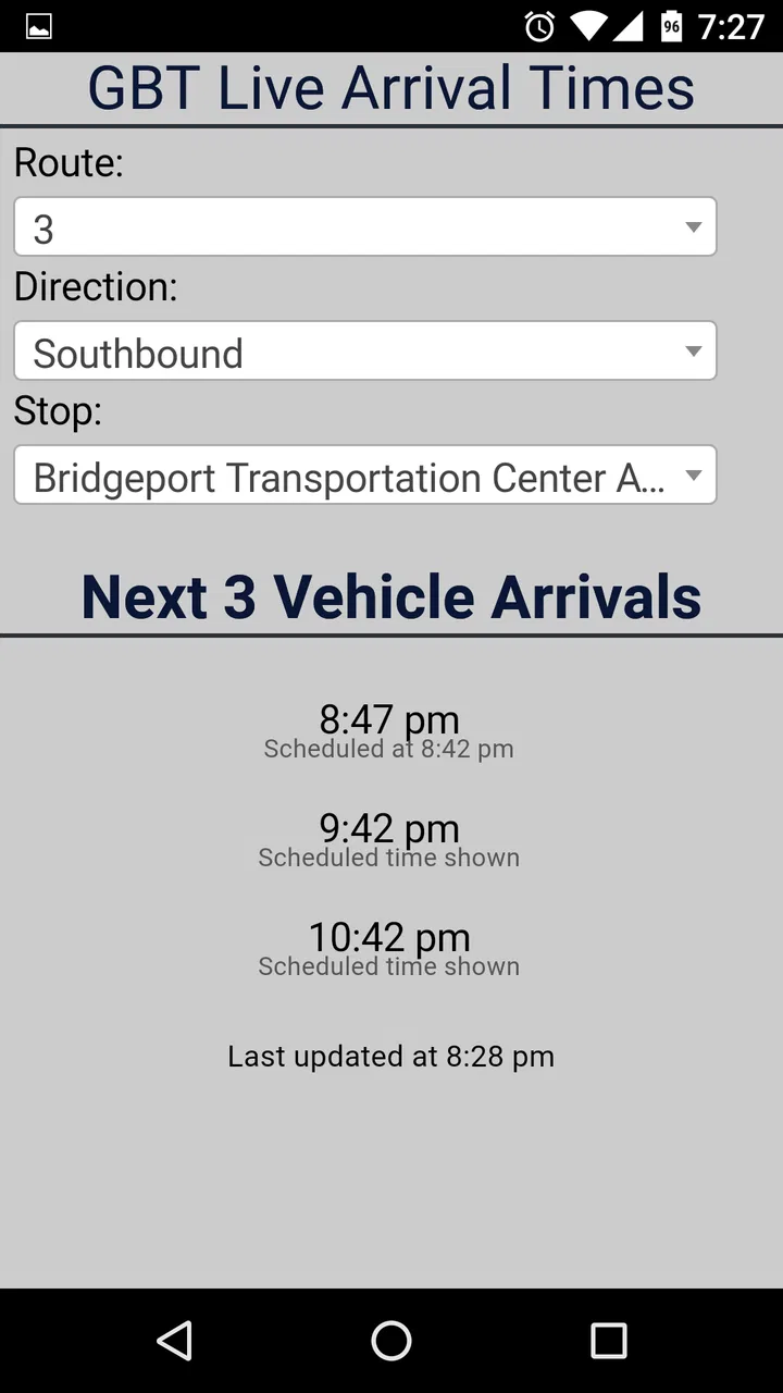
Bridgeport GBT Bus Tracker is designed to help passengers follow Greater Bridgeport Transit buses in and around Bridgeport, Connecticut. After opening the app, users can typically view routes, stops, scheduled information, and estimated arrival times. It is especially useful when you are waiting at a stop and want a better idea of when the next bus may arrive, although estimates can change with traffic or service conditions.
02Does Bridgeport GBT Bus Tracker show real-time bus locations?
The app is intended to provide live or near-real-time transit information for GBT services, including vehicle locations and predicted arrivals when data is available. However, the accuracy depends on the bus transmitting a valid location and on the transit agency’s data feed. During technical problems, poor connectivity, detours, or delays, the displayed position or arrival estimate may be incomplete or different from what you see on the road.
03Can I use the app to find routes and nearby GBT bus stops?
Yes, route and stop information is one of the main reasons to use Bridgeport GBT Bus Tracker. You can generally browse available GBT routes, select individual stops, and check upcoming departures. Depending on your device settings and the app’s supported features, location access may help identify nearby stops. It is still wise to confirm the selected direction, because stops on opposite sides of a street may serve different routes.
04Does Bridgeport GBT Bus Tracker work without an internet connection?
An internet or mobile-data connection is normally required for current arrival predictions, vehicle positions, and service updates. Some basic route or stop information may remain visible after it has loaded, but the app cannot refresh live data while offline. If you are traveling with limited connectivity, open the relevant route or stop before leaving and keep an official schedule or alternate trip-planning option available as a backup.
05Is Bridgeport GBT Bus Tracker free and what permissions might it request?
The app is generally available as a free download, though normal mobile-data charges may apply when retrieving live transit information. It may request location permission to show nearby stops or personalize results, while notifications could be used for service alerts if supported. You can review and change these permissions in your Android or iOS settings. Before downloading, check the current store listing for pricing, compatibility, privacy details, and developer information.
Pros
- Shows real-time bus locations and estimated arrival times.
- Helps plan trips using Bridgeport GBT routes and stops.
- Useful for checking service information while traveling.
- Simple interface makes regular route searches quick.
- Can reduce waiting time by providing updated arrival data.
Cons
- Arrival predictions may be inaccurate during traffic or service disruptions.
- Coverage is limited to Greater Bridgeport Transit services.
- Requires an internet connection for live tracking updates.
- Some stops may have incomplete or outdated information.
- The app may offer fewer planning tools than larger transit apps.

Bridgeport GBT Bus Tracker
Gallery